4d5fa84184
Add class=pond to the water layer ( #1456 )
...
This PR proposes to add a new class, "pond" to the water layer, which allows for a style to de-emphasize minor bodies of water (tagged `water=pond,basin,wastewater`) when compared to more significant objects tagged reservoir/lake. This PR retains the default behavior of classifying a water body as a "lake" if more specific tagging is not added.
2023-01-06 08:44:11 +01:00
5e51627895
Remove support for waterway=riverbank ( #1405 )
...
This PR removes support for `waterway=riverbank`. Usage of waterway=riverbank has [declined to globally insignificant levels](https://taginfo.openstreetmap.org/tags/waterway=riverbank ).
In other projects:
* Support for `waterway=riverbank` was removed from the iD editor in openstreetmap/iD#5591
* Removal of `waterway=riverbank` was tracked for JOSM in [JOSM ticket 21630](https://josm.openstreetmap.de/ticket/21630 ) and was completed in revision [18519](https://josm.openstreetmap.de/changeset/18519/josm )
* Removal of `waterway=riverbank` from openltmap (Lithuania vector map) occurred in [[1]](507f095b35
2022-07-26 14:34:02 +02:00
5820534153
Add swimming pool to class attribute. ( #1385 )
...
This PR adds swimming pools as a class in the water layer. Until now all swimming pools were classified as `lake`.
2022-05-05 20:57:51 +02:00
d427d58e36
Water layer river mapping bug fixes ( #1182 )
...
This PR is a bugfix for the `water` layer.
* `waterway=stream`, `waterway=river`, `waterway=canal`, `waterway=ditch`, and `waterway=drain` are all linear features, not area features. Thus, these objects are being unnecessarily mapped into the `osm_water_polygon` polygon table, and this PR removes these unneeded mappings.
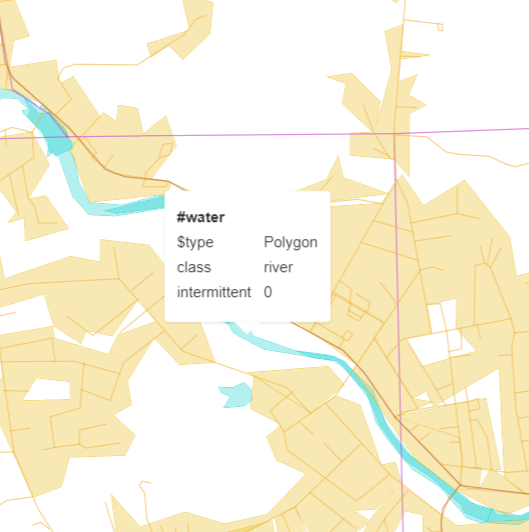
* The combination `natural=water` + `water=river` is the most popular tagging for river areas. However, the current mapping causes rivers tagged in this way to be rendered in the vector tiles as a `lake`. This PR adds a check for the `water=river` tag and tags both variants of river areas as `class=river`.
`natural=water` + `water=river` river mapping:
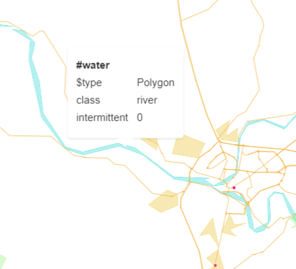
`waterway=riverbank` river mapping:
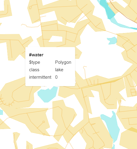
Lake mapping for a `natural=water` (with no other tagging):
2021-09-01 08:24:01 +02:00
e37076c133
Add spring water bodies ( #1167 )
...
The [OSM wiki](https://wiki.openstreetmap.org/wiki/Tag:natural%3Dspring ) says `natural=spring` may be used on areas.
2021-08-18 17:46:15 +02:00
77f5d76e37
Refactor schema, one _gen_z view per zoom. ( #1045 )
...
* Refactor layer aeroway.

* Refactor layer boundary.

* Refactor layer landcover.

* Refactor layer landuse.

* Refactor layer park.

* Refactor layer transportation.

* Refactor layer water.

* Refactor layer waterway.

* Re-generate water* layers etl_diagrams.

* Regenerate etl_diagrams for waterway.

* Cast NULL to text.
2020-11-26 13:54:00 +01:00
a3ce04fe23
Add landuse=salt_pond as water ( #1000 )
...
Add salt pond as water.

Most of salt pond are already tagged with natural=water even if it's not required. So the load added by this tag is very light.
2020-09-29 07:53:35 +03:00
e808590a4a
Add landuse=basin as water ( #876 )
...
Add support of tag landuse=basin as water polygon.
2020-05-22 14:45:18 +02:00
f5d34b5949
Mapping leisure=swimming_pool as water ( #878 )
...
Adds tag leisure=swimming_pool as water polygon
2020-05-22 10:31:47 +02:00
9d6dbfc64f
Use one pass docs image generation ( #751 )
...
quicker and cleaner diagram image generation.
Remove etl-graph and mapping-graph targets - redundant

Also, the obsolete "fields" is still in Imposm's code and both names are accepted,
but "fields" is not documented anywhere (PR submitted), and could be removed at any moment.

Our docs were not supporting it until this PR, so renaming it at the same time.

Several images have been updated due to a more inclusive mapping scan
Requires https://github.com/openmaptiles/openmaptiles-tools/pull/147 (merged)
2020-01-22 21:55:22 -05:00
90c4854184
removing webmerc_area
2019-11-19 16:36:00 +01:00
23358f18af
add brunnel info for water
2019-10-11 17:57:26 +02:00
7a3ac079ae
Add intermittent field to water* layers ( #430 PR #585 )
2019-05-24 13:21:43 +02:00
8766a0effc
Add waterway:dock to water layer
2018-11-11 16:48:37 +01:00
5c67f2769e
Add st_isvalid check to imposm3 generalized tables
...
Fix #386
2018-01-31 17:24:05 +01:00
51bc8fad35
Multilinguality ( #279 )
...
Improve multilinguality: names in 57 languages, name:latin, name:nonlatin, name_int. Fixes #211 #252 #80 .
See #279 for more info.
2017-06-12 17:53:47 +02:00
555825486f
Adjust tolerance for transportation and water ( #257 )
2017-05-23 11:55:45 +02:00
4037256d43
Eliminate features with area<4px for aeroways, parks and water
2017-05-22 19:03:44 +02:00
90690d2a39
Switch to ZRes ( #214 )
2017-04-25 18:03:29 -04:00
3e6495a134
Import both area and webmerc_area, use area for filtering ( #198 )
2017-03-24 16:46:21 +01:00
4c6d30066d
Add German names (name_de), unify English names (name_en)
2017-03-17 12:56:54 +01:00
0b3177de00
Fix openmaptiles/openmaptiles#78 , Switch to OSM water bodies in z6
2017-03-15 17:29:06 +01:00
a865d6c970
Merge branch 'master' into imposm3_filter_reject_require
2017-01-18 15:39:40 +01:00
5b430f4b83
Remove commented out code
2017-01-18 15:06:24 +01:00
8273bfbb62
Switch to webmercarea
2017-01-17 09:45:58 -05:00
40884b9976
imposm3 mapping change to the new reject/require syntax
2017-01-07 14:55:08 +01:00
87120e1658
Remove waterway constraint for water polygons #120
2017-01-04 14:15:52 +01:00
30747a3bc8
Use different generalization levels at zooms
2016-11-29 09:47:02 +00:00
05992e066c
add etldoc to layer_water
2016-11-10 14:08:39 +01:00
90f2203e7c
Document water and remove obsolete mapping
2016-10-28 20:49:20 +02:00
ea2530788f
Filter out large rivers
2016-10-28 16:53:29 +02:00
9c50026f16
Remove osm_id in vector tiles coz of huge size savings
2016-10-25 19:15:51 +02:00
c86f5b9a26
Switch water layer to imposm3
2016-10-10 19:39:47 +02:00