9e74fb6299
Fix park layer ETL diagram ( #1278 )
...
This PR fixes an ETL diagram documentation error in the park layer.
2021-10-25 08:12:17 -04:00
f744f9c009
Upgrade to omt-tools v6, Imposm 0.11.1 and migrate SQL ( #1246 )
...
This PR migrates the SQL in the transportation and transportation_name layer to use the new imposm3 mappings which now map a separate primary key ID.
2021-10-14 11:38:28 -04:00
0e17d53f42
Implement park rendering at z4-5 ( #1160 )
...
Unblocks ZeLonewolf/openstreetmap-americana#51
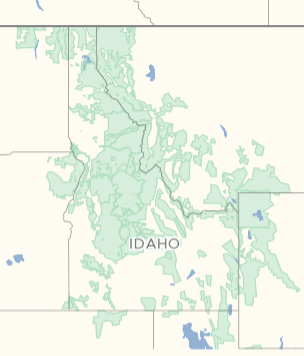
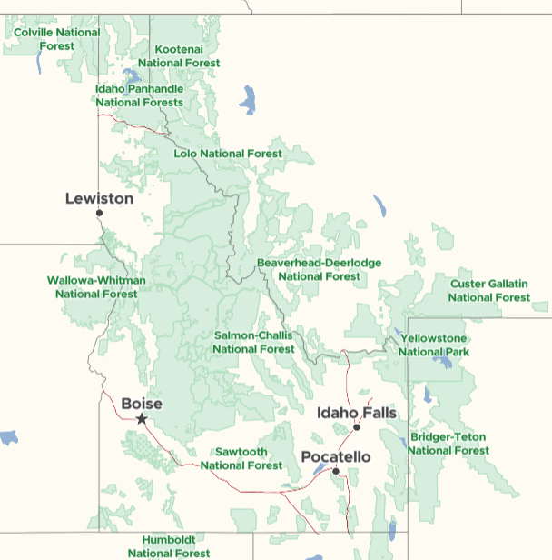
Currently, OpenMapTiles renders protected areas at zoom 6 and higher. However, the western United States has protected areas that are so vast that it makes sense to render these areas as low as zoom 4, as noted in ZeLonewolf/openstreetmap-americana#51
This PR extends the generalization of park features from its current termination at zoom 6 to zoom 4.
Here is an example from the Americana style of rendering protected areas at zoom 6, which is currently the lowest supported zoom:
https://zelonewolf.github.io/openstreetmap-americana/#6/45.313/-111.721
We would like to provide rendering at zoom 4 (no labels) and zoom 5 (with labels) in the Americana style. Below are samples generated from this PR for Idaho, USA:
Zoom 4:
Zoom 5:
2021-09-01 07:20:52 +02:00
77f5d76e37
Refactor schema, one _gen_z view per zoom. ( #1045 )
...
* Refactor layer aeroway.

* Refactor layer boundary.

* Refactor layer landcover.

* Refactor layer landuse.

* Refactor layer park.

* Refactor layer transportation.

* Refactor layer water.

* Refactor layer waterway.

* Re-generate water* layers etl_diagrams.

* Regenerate etl_diagrams for waterway.

* Cast NULL to text.
2020-11-26 13:54:00 +01:00
2edbbfa1a0
Updated etl diagrams from latest tools
...
* gets rid of duplicate connecting lines in etl graphs
2020-02-14 16:22:48 -05:00
eca13f9bed
Refreshed all diagrams, fixed automation & 2 broken graphs ( #692 )
...
Seems like etl and mapping diagrams have been neglected
for a long time. Now it regenerates the files and places
them in the source dir.

This PR also fixes two broken files:
* layers/aerodrome_label/mapping_diagram.png
* layers/housenumber/mapping_diagram.png

They were generated using the newest tools version with the fix
https://github.com/openmaptiles/openmaptiles-tools/pull/65
2019-10-26 21:28:43 -04:00
cd920755bf
Remove park_label layer, add labels to park layer
2018-11-07 18:22:26 +01:00
ccf8ee6dfa
Add park labels layer
2018-11-05 16:40:32 +01:00
3cee3c7f80
Update diagrams
2017-12-04 12:06:28 +01:00