6212c056ea
Added quarry to landuse list ( #1404 )
...
This includes quarry in the list of landuse features

Co-authored-by: Tomas Pohanka <TomPohys@gmail.com>
2022-09-08 11:43:48 +02:00
f744f9c009
Upgrade to omt-tools v6, Imposm 0.11.1 and migrate SQL ( #1246 )
...
This PR migrates the SQL in the transportation and transportation_name layer to use the new imposm3 mappings which now map a separate primary key ID.
2021-10-14 11:38:28 -04:00
d186856ac5
Add support for cemetery tagged as grave_yard ( #1175 )
...
Fixes #1057
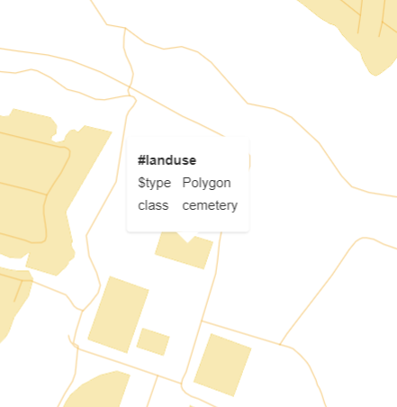
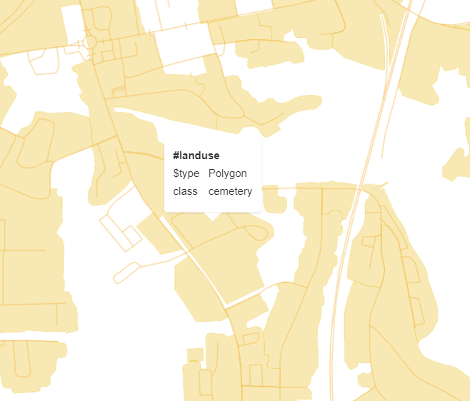
This PR adds `amenity=grave_yard` to the `landuse` layer. A unification function was implemented which encodes all `class=grave_yard` as `class=cemetery` in the tiles, which adds these features for existing users of `class=cemetery` with no change. The unification function can serve as a basis for any other tags that we might want to unify in the `landuse` layer.
Tile rendering for an `amenity=grave_yard`. ([Location](https://www.openstreetmap.org/way/857383420 ))
Tile rendering for a `landuse=cemetery`. ([Location](https://www.openstreetmap.org/way/385779531 ))
2021-08-18 09:09:51 +02:00
295688eb80
Add place=quarter to city subdivisions ( #1065 )
...
This adds `place=quarter` which was introduced in 2011 as a subdivision
of villages/towns/cities as a value that sits between `place=suburb` and
`place=neighbourhood`. It has by now been used over 40,000 times and is
rendered in the OSM-Carto.
2021-01-18 14:47:25 +01:00
7f591ffebc
update the 'layers/landuse/mapping_diagram.png'
2019-12-06 19:48:56 +02:00
fcee8571fb
adding waterway=dam
2019-11-20 18:05:07 +01:00
eca13f9bed
Refreshed all diagrams, fixed automation & 2 broken graphs ( #692 )
...
Seems like etl and mapping diagrams have been neglected
for a long time. Now it regenerates the files and places
them in the source dir.

This PR also fixes two broken files:
* layers/aerodrome_label/mapping_diagram.png
* layers/housenumber/mapping_diagram.png

They were generated using the newest tools version with the fix
https://github.com/openmaptiles/openmaptiles-tools/pull/65
2019-10-26 21:28:43 -04:00
7b6c4752e9
add leisure=track
2019-05-15 18:05:44 +02:00
2f151a833d
Update landuse documentation & diagram
2018-01-12 15:43:33 +01:00
8e84f419d7
Add pitches and playgrounds to landuse
2017-11-08 14:05:34 +01:00
1b01399e1d
Update diagrams
2017-06-12 18:13:09 +02:00