6212c056ea
Added quarry to landuse list ( #1404 )
...
This includes quarry in the list of landuse features

Co-authored-by: Tomas Pohanka <TomPohys@gmail.com>
2022-09-08 11:43:48 +02:00
e079e82cb1
Better generalization for `landuse=residential`. ( #1414 )
...
This PR creates larger polygons of `residential` land-use areas for upper zoom levels (especially for zoom 6 - 10).
Clusters are created with the same logic as for [`building on z13`](b14da2eafb/layers/building/update_building.sql (L34-L49)
2022-09-02 10:01:41 +02:00
ebeafc65fa
Add requires.tables to <layer>.yaml ( #1236 )
...
**NOTE** this can only be merged after the next tools version is released.
Added required Postgres tables to the `<layer>.yaml` definition.
Close : #1220
PR of tools: https://github.com/openmaptiles/openmaptiles-tools/pull/370
2021-11-05 10:04:54 +01:00
d186856ac5
Add support for cemetery tagged as grave_yard ( #1175 )
...
Fixes #1057
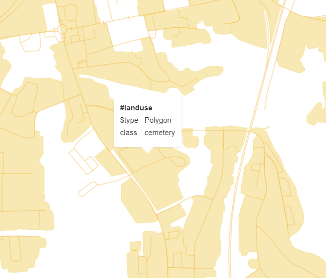
This PR adds `amenity=grave_yard` to the `landuse` layer. A unification function was implemented which encodes all `class=grave_yard` as `class=cemetery` in the tiles, which adds these features for existing users of `class=cemetery` with no change. The unification function can serve as a basis for any other tags that we might want to unify in the `landuse` layer.
Tile rendering for an `amenity=grave_yard`. ([Location](https://www.openstreetmap.org/way/857383420 ))
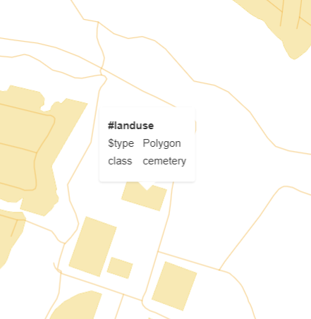
Tile rendering for a `landuse=cemetery`. ([Location](https://www.openstreetmap.org/way/385779531 ))
2021-08-18 09:09:51 +02:00
295688eb80
Add place=quarter to city subdivisions ( #1065 )
...
This adds `place=quarter` which was introduced in 2011 as a subdivision
of villages/towns/cities as a value that sits between `place=suburb` and
`place=neighbourhood`. It has by now been used over 40,000 times and is
rendered in the OSM-Carto.
2021-01-18 14:47:25 +01:00
2aa9630b41
add forgotten 'garages' landuse to the docs ( #1059 )
...
In https://github.com/openmaptiles/openmaptiles/pull/720 I've forgotten to add the `garages` class to the docs. This PR is fixing that issue,
2020-12-29 14:26:14 +02:00
fcee8571fb
adding waterway=dam
2019-11-20 18:05:07 +01:00
7b6c4752e9
add leisure=track
2019-05-15 18:05:44 +02:00
c320b92a4b
place=suburb and place=neighbourhood added
2019-04-11 11:57:07 +02:00
2f151a833d
Update landuse documentation & diagram
2018-01-12 15:43:33 +01:00
940f70a415
Handle theme_park as a landuse
2018-01-12 15:40:54 +01:00
8e84f419d7
Add pitches and playgrounds to landuse
2017-11-08 14:05:34 +01:00
6ff8fd7c20
Fix docs in landuse, place and poi
2017-01-05 16:46:11 +01:00
915cd2bde3
Add possible values for landcover, landuse, park doc
2016-11-30 11:21:13 +00:00
4a902ca273
Extend docs for park, landuse, landcover
2016-11-30 09:32:25 +00:00
263d7e8a96
Add docs for landcover, landuse and housenumber
2016-10-30 16:07:47 +01:00
9c50026f16
Remove osm_id in vector tiles coz of huge size savings
2016-10-25 19:15:51 +02:00
bdea298990
Introduce landuse classes
2016-10-24 14:28:09 +02:00
79d04f3792
Integrate urban into landuse
2016-10-24 12:02:33 +02:00