kopia lustrzana https://github.com/geodienst/lighthousemap
20 wiersze
1.7 KiB
Markdown
20 wiersze
1.7 KiB
Markdown
# Beacon map
|
|
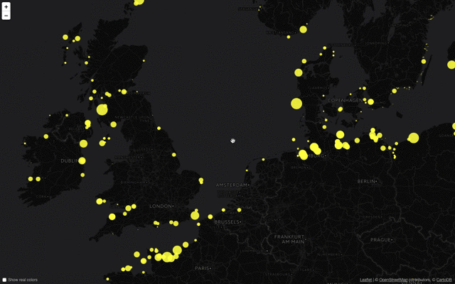
This map shows all the blinking beacons from [OpenStreetMap](https://www.openstreetmap.org/).
|
|
|
|
|
|
|
|
More specifically, it asks the [Overpass API](https://www.overpass-api.de) for all elements with an `seamark:light:sequence` or `seamark:light:1:sequence` attribute, decodes these, and displays them as coloured circles on the map using [Leaflet](https://leafletjs.com). It also tries to take the `seamark:light:range` and `seamark:light:colour` into account.
|
|
|
|
If you think a lighthouse or beacon is missing, please add or edit it on [OpenStreetMap](https://www.openstreetmap.org/).
|
|
|
|
## Overpass API
|
|
The current version uses an extracted dataset, but the code allows for directly querying the Overpass API. However, since a query like the one used here can take multiple minutes to complete it is not very useful do always do live queries. Currently we're updating the data every night.
|
|
|
|
## Useful stuff
|
|
The `leaflet.indexedfeaturelayer.js` file contains an extension on Leaflet's GeoJSON layer that only add layers/features to the map that are (or are about to be) visible. It uses a spatial index to quickly query which features can be removed from the DOM, increasing performance.
|
|
|
|
`leaflet.light.js` contains my best guess on how a light sequence will look based on [these descriptions](https://wiki.openstreetmap.org/wiki/Seamarks/Light_Characters). However, it might be inaccurate, and it tries to do its best with the sometimes not entirely consistent data from OSM.
|
|
|
|
## Credits
|
|
This map is made by the [Geodienst](https://www.geodienst.xyz) because it was a fun idea we wanted to try out. Feel free to fork this map and make your own visualisation of OSM data, or contribute improvements back to us.
|